Animal-vehicle collisions frequently occur along major highways in the province of British Columbia and the Elk Valley Wildsight branch has developed a mobile app and online mapping system to reduce animal mortalities and improve human safety. The RoadWatchBC system allows citizens driving in the Elk Valley to report animals they see in an effort to track animal movement on the major roadways.
“The manner in which we are able to do this is by developing a mobile app and online mapping tool. With the mobile app, people are able to use it if they’re a passenger in a vehicle. We don’t encourage drivers to use the app, but if you’re a passenger in a vehicle and you see a deer standing beside the road, you can bust out your phone and immediately submit an observation saying there’s a deer standing beside the road. It will record your GPS and the time and all that data is uploaded into our system,” said local project lead Beth Millions.
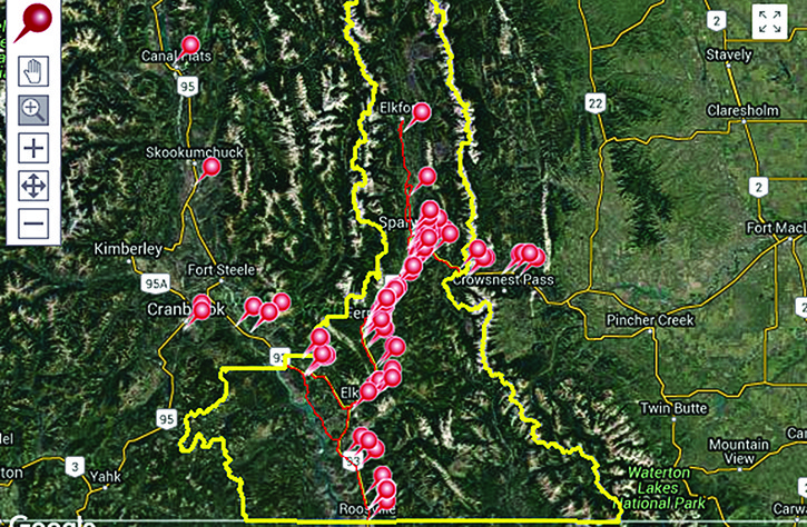
RoadWatchBC also has an online mapping system so drivers can report an observation after they arrive safely at their destination. The idea is that Wildsight Elk Valley can collect this data to see where the animals are moving and get an idea where along the highways they’re likely to be.
“Anywhere there’s a one-kilometre stretch of road in a year sees greater than approximately three deer collisions. It’s more cost effective to put in a form of mitigation such as an underpass with fencing in order to stop people from hitting animals,” said Millions.
Once they figure out the points most travelled by wildlife, Wildsight will then present the data to the B.C. Ministry of Transportation with the aim of working together with the province to establish forms of mitigation such as fencing, underpasses, and animal detection systems.
The program follows a similar system established in Crowsnest Pass in Alberta that collected data for 10 years before beginning mitigation. The Crowsnest Pass system started before mobile apps were around so the mobile app is unique to the Elk Valley. The RoadWatchBC program was implemented on roughly a month ago on June 22nd and so far the program has reported five successful highway crossings by wildlife and six mortalities — five of deer and one elk.
“What’s really important too is that the people who are involved in this project — and that’s anyone volunteering — really shows their support in it. That’s how we make a difference, that’s how were going to actually get the government to change (its policies). It’s unfortunate, but that’s just kinda the way it goes; you have to show the community cares about it,” said Millions
The RoadWatchBC program is currently only running in the Elk Valley but motorists can download the app and report animal sightings in other areas. According to the RoadWatchBC website, in the Columbia Valley there have been two reports of deer on the road, in Radium and in Canal Flats. Data collected from other areas outside the Elk Valley will be used if the RoadWatchBC program expands into other regions of the province.
To learn more and to download the app, visit http://roadwatchbc.ca.