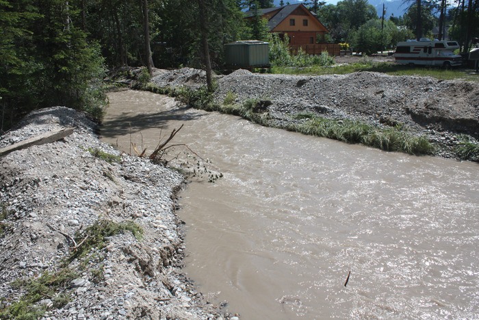
While the rains have stopped for the time being, the aftermath of some of the highest water levels in recent memory are still being felt across the region. Most notably, at Shadybrook Resort in Windermere, crews are still fighting to lower the level of Windermere Creek, as owner Mike DuBois says the water has been rising almost as quickly as they can excavate gravel from the bed of the creek.
“After eight hours of digging, the water dropped 16 inches, but overnight it filled up with eight inches of gravel,” DuBois said on Friday (July 6).
After a state of emergency was declared for the resort by the province late Saturday (June 30) evening, DuBois immediately began to excavate gravel using his own equipment. He managed to return about 90 per cent of the Windermere Creek flow back to its original channel, but without outside help was fighting a losing battle.
“In the following days, no matter how much I dug, I couldn’t keep up with the debris flow,” DuBois said.
Larger equipment and contractors — paid for with the help of provincial emergency funds — arrived on Tuesday (July 3), however the province is only allocating funds to excavate the creek and nothing to help with the cleanup at Shadybrook. At press deadline, those funds had been used up and DuBois said meetings were underway to determine whether further funds should be allocated. He has not heard any form of resolution regarding fixing the source of the problem further upstream.
“Just with this year’s work, the province has probably spent $300,000 [in emergency funds] and the permanent solution upstream would be a $2,000 fix,” DuBois said.
Studying the problem further to avoid future damages could raise the total cost of any solution to $25,000, he said.
Without a permanent solution to restore the creek to its original channel upstream — thereby reducing the gravel intake — it’s likely the creek will continuously overflow its boundaries until water levels drop significantly.
“There’s no end in sight, but if the water levels drop then [the creek] won’t have the ability to transport [gravel] down as fast,” DuBois said. “It’ll keep coming all summer, just to a little lesser extent.”
The Regional District of East Kootenay, which administers the provincial emergency funds, could not be reached for comment, but released the following in a July 4 release: “We have been working with the Province to get the approvals to do the work within the creek channel and have been given the green light for two days of equipment time,” emergency operations centre director Brian Funke said in the release. “The work will focus on removing the buildup of sediment and gravel in the lower portion of the stream bed, with the hopes of returning the creek back to its channel. We have been working with the property owners and the Ministry of Forests, Lands and Natural Resource Operations and are pleased to see the work approved and moving forward.”
Elsewhere in the region, in Kootenay National Park, park workers are attempting to salvage a number of damaged bridges after high water levels caused massive damage.
“We’re still living with the aftermath of this once-in-a-generation event,” said Parks Canada communications officer Omar McDadi.
Much of the damage is focused in the northern end of the park and McDadi said the southern portion of the park near Radium Hot Springs is still in fair to good condition. Water levels have receded to some degree and Parks workers are assessing which bridges can potentially be salvaged.
“It’s a big job, so we’re prioritizing our work,” explained McDadi. “We’re making every reasonable effort possible to salvage some bridges.”
Two of the most badly affected trails are Paint Pots and the Rock Wall trail, but McDadi said efforts are being made to open up additional access points and alternate routes of travel to these areas. Although badly damaged trails are marked with the appropriate signage, McDadi said the best way to check trail conditions is to visit the Kootenay National Park website at www.pc.gc.ca/pn-np/bc/kootenay and click on the Trail Conditions Report section of the website.
“There are still a lot of visitor opportunities,” McDadi said. “There’s still a lot of things for people to do as we head into this busy part of the year.”